Friday, September 29, 2017

Friday, September 29, 2017

We're shot!  No, not bullet shot, just tired!  It's a good tired, though, as we stayed in the park all day.  They have geo-caches here and it involved some hiking, climbing up the hillside (they call them mountains out here), and then getting back down!  What a fun day, we had!  We found all twelve caches that we looked for, and some were terrain difficulty of 4, which means, old people shouldn't be doing them!  We'll sleep well tonight.  There was a reason why we couldn't find a decent campground in the vicinity, and we couldn't be happier with Guernsey State Park.  The cost of the state parks to stay in, is about half of what a private campground costs.  Of course, we don't have the amenities of a full campground, but the charm and uniqueness of the state parks, is worth 'sacrificing a few luxuries' when camping.  This is a large park, consisting of 6,227 land acres and 2,375 water surface areas.  The sad part of it is that, they had a wildfire in 2012 and it burned a good portion of the park.  It has a very nice museum, and the structures, trails and bridges were built by the CCC.  They were quite the artisans!  They have a picnic shelter in the park and they call it 'The Castle'.  It is jaw dropping beautiful.  We ended the day by going to the Stockmen and Miner's Restaurant and Steakhouse in Hartville.  It is known to be Wyoming's oldest bar.  The back bar dates back to circa 1862, and was made in Germany and shipped over here.  Hartville is the oldest incorporated town in Wyoming.  I found that bar/restaurant when we were back in Wisconsin and it was on our MSN page as a great place to eat.  It lived up to its bragging rights!   I tried to upload some pictures, but our internet is so poor, that it won't work.  I'll resend them when we get to Loveland on Sunday.
We're in Loveland now, and will upload the pictures for Friday and then do our blog for Saturday and Sunday combined. 
These two little twin cuties crossed the road in front of us, and I didn't even have to zoom in on them.  They acted like they hadn't seen anything like us before!

We saw several of these picnic areas that, were constructed by the CCC and thought how ingenious of them to use the support poles and incorporate it into the picnic table!  They had a beautiful fireplace alongside of this structure (in the background). 

This extraordinary building was the most lavish park shelter that we have ever seen.  It had a spiral staircase that led to a wonderful view of the lake below.  They name this 'The Castle' and it so deserves that name.

This view is from the side of  'The Castle' and you can see how intricate the design is for this park shelter.  There is a picnic table inside and a fireplace, as well.

This view from the top of 'The Castle', give you a good idea of the landscape and a portion of the lake in Guernsey State Park.  We drove every road (gravel and otherwise) and covered the whole park.  It was a wonderful way to get acquainted with the park.  It literally, took us all day!

This is the oldest bar/restaurant in Wyoming, and it dates back to the 1860's.  These are the unusual and fun places we like to find in our travels.  They had a gourmet type meal, and one wouldn't expect that here.  It was the end of a very fun and exhausting day! 


Thursday, September 28, 2017

Thursday, September 28, 2017

We left Sundance, Wyoming this morning and took the Scenic Byway down to Guernsey, Wyoming.  We will be staying here three nights, and then Sunday, we arrive at Loveland, CO.....back to civilization!  We are in the boonies, if there is such a thing in Wyoming.  Mostly, we saw wide open spaces, huge ranches, lots of horses and cattle and again, so many Pronghorn Sheep!  I am going to get up close to one to get a good picture, before I'm done here!  We also saw a lot of the wooden snow fence along the highway, as the road runs north to south, and we are east of the mountains, so I'm sure they get lots of snow in the wintertime.  Their roads are wonderful, but not many people on them.  We are in a state park near Guernsey, and have water and electric hook ups, and the spaces are huge, and open, but it looks like they had a terrible fire in the park, not too long ago.  Both sides of the road was burned as we drove in the first part, but we see no sign of fire, where we are parked.  That is so tragic when you see the forests burned out.  We have no over the air television, so Jim is setting up our DirecTV dish, so we can at least, keep up with the news and weather.  We are back to sand burr country!  They are nasty!  I have about 40 caches loaded for the area, and it looks like a very interesting stay.  I'm going to convert all of you followers, to become a geo-cacher, before we're finished with this trip.  Honestly, if it weren't for geo-caching, we wouldn't be seeing all of these interesting places.  The trees are very green here yet, so we're happy about that.  We know the higher elevation in the Rocky Mountain Nat'l Park will have a different look.  The Aspen and Birch trees are glowing gold right now, I'm sure.  I do think we will be hitting it at a good time next week.  So, if you don't hear anything from us, it's because of lack of internet service.  I won't even try to post pictures on here today, because our Verizon MIFI is 1X and 2 bars!  Not good.  I promise to bombard you with pictures and information when we get to our next place on Sunday!  Our phones don't work here, either, so we'll check them when we go caching tomorrow. 

Wednesday, September 27, 2017

Wednesday, September 27, 2017

We waited for today to do our loop drive west of Sundance to Devil's Tower, northwest of here.  It is the first National Monument established in the country in 1906 by President Teddy Roosevelt.  The 'tower' was formed by magma which cooled underground and was later exposed after millions of years of erosion, brought on by the Belle Fourche River and the weather.  We hiked the 1.3 mile circumference, which was all a paved trail.  We can hardly call that hiking!

The tower is over 600 feet high and the columns are 10 to 20 feet wide. We actually, saw some people repelling the tower. 

This is an antique shop in the small town of Hulett.  It's customary to pile racks of deer antlers on the outside of the buildings. 

A geo-cache brought us to this coal mining 'tipple'.  The coal is extracted from the mine above, pulled by mule and cart or wagon to the entrance of the mine, and it was sorted at the top and rolled down the chute to waiting railroad cars.  It was transported to Lead and Deadwood, SD to the gold smelters there.  It is believed to be the last wooden such structure remaining in the west.  This coal mine was in operation from 1898 and closed in 1940.  The miners were mostly Europeans looking for a better life. 

This is one of many buffalo jumps that are found throughout the western part of the country and into Canada.  It was closed, so we didn't get to see the actual remains area.  The Indians would round up the buffalo and run them off the deep end of the cliff, where they were killed and butchered for their meat and hides.  It was stated previously in a museum, that the women were the ones that removed the hides, which was very hard labor.  This particular jump was used from 1500 to 1800 A.D.

A geo-cache brought us here, also.  We actually, saw it move with the wind.  It is a small plane and it's a weather vane! 

                                              Can everyone ride a horse without a bridle? 

We stopped at the Visitor Center (for another geo-cache) and get some information on our next stop.  I saw this display, and just had to end our wonderful stay with this.  If you can read the headline on the photo, it's "Westward Ho".  So far, it has been Happy Trails, though!  We loved Sundance and the history of it all.  Tomorrow we move to Guernsey State Park.  We've had a hard time finding a suitable campground in the area we want to stay next, so we settled for this one.  We do like the state parks out this way, so I'm sure it will be fine. 


Tuesday, September 26, 2017

Tuesday, September 26, 2017

This morning was foggy, windy and chilly, so we had a slow start to our day, but it was okay.  We wanted to go to the museum in Sundance and get the passport for geo-caching, and see what we needed to do.  We had to get ten caches that they listed and every cache had a password, that we needed to register on the passport.  We got all ten in Sundance.  They took us to interesting places and gave us some exercise.  Tomorrow we will try to get the other coin and that involves going to Devil's Tower, which is northwest of here.  We'll do the loop to make it a full day, and more fun caching. 

This geo-cache took us to the statue of the Sundance Kid.  I'll call this photo, 'Butch Cassidy and the Sundance Kid'!  He was a scoundrel and spent more time in jail than outside. 

Another geo-cache took us to the top of Warren Peak, where there is a lookout tower to watch for wildfires in the area.  It's very pretty up here, but photos didn't show it.  The Birch and Aspen trees are very golden here, so mixed in the pines, it was pretty.  This is located northwest of Sundance about 6 miles up. 

                                    This is the old bank in Sundance, that dates back to 1912.

We ended our day at the Longhorn Saloon, where they had sixteen beers on tap.  It was a beautiful place and from what we hear, it's a good eating place.  We have bean and ham soup to eat!   We met a couple from south of Racine, that had moved out here about 12 years ago.  They love it here, and I can understand why.  It's pretty laid back.


Monday, September 25, 2017

Monday, September 25, 2017

We left our very nice campground east of Belle Fourche, SD this morning and drove in a fog and drizzle for our short drive today.  We arrived in Sundance, Wyoming and the weather hasn't changed.  We haven't reached 50 degrees today, but the forecast looks better.  We did hole up yesterday and caught up on our rest, and I made some ham and bean soup for our duration here.  We always buy Nueske's bone in ham steaks and it makes great soup!  We are so fortunate to live so closely to Nueske's!  It's a wonderful meat processing plant in Wittenberg, and they are about 5 miles from us.  We saw 4 deer running just off the campground area, and were told that we shouldn't drive at night, due to the herds of deer running around here.  We will check the town out tomorrow and do some geo-caching, and save Wed. for our trip to Devil's Tower. 

Oh, yum!  I also made an apple pie from scratch, yesterday.  We bought some apples for the road, at Wilson Creek Orchard, just before we left home and we had enough for this pie!  I'll just call it a 'taste from home'.  The orchard is only a few years old and it's only a few miles from us.  Again, we are so lucky to be positioned where we are.

Due to time on my hands and two rainy days, I finished the baby quilt that I was knitting.  This is folded four times, so it isn't that small!  We have no grandchildren married, or even thinking about it, but I want to be ready!  Once the great-grandchildren start coming, they can come fast!  I will stock up on yarn in Loveland, CO when we get there, and start another one.  I'm a Type A person, and I just can't sit and do nothing.  I am sure most of you know that about me.

       Through the fog and drizzle, you might be able to make out the 'Welcome to Wyoming' sign.

                    This greeted us at the front door of the campground office.  Self explanatory!

We have this buckboard wagon right next to our site, so I guess we are out west! It's a nice campground, but we are noticing the soil here is clay and silt, so we are pretty dirty!  Maybe it will rain tonight!  We notice the heat is still with you people back in Wisconsin and east of there.


Saturday, September 23, 2017

Saturday, September 23, 2017

As predicted, we had a rainy day today, so we went into the museum in Belle Fourche.  We did watch the Brewers win their game today.  Finally!  They couldn't lose another 10th inning game to them!  We had a geo-cache our first day in, that took us to an area just south of where we are camped.  During the war, many buildings were constructed to house the POW'S from Germany.  The buildings were either moved into Belle Fourche or torn down. One of the buildings houses the VFW in Belle Fourche today.  At the museum today, we got a little more information on that situation.  There were about 400,000 German soldiers captured during the war and brought over here to help fill the massive labor shortage the United States faced because millions of the GI's were overseas.  One 17 year old German soldier said, "As soon as we were in American hands, we had it good.  All of the things we suffered through in Germany, especially hunger, had vanished just like that.  Everything was perfect."  The POW'S that arrived, helped harvest the sugar beets in the Belle Fourche Irrigation District.  They were trucked to the scheduled farms in the morning and returned at 6:00 p.m.  They received $0.80 a day in canteen coupons.  They couldn't buy beer, cigarettes, candy or soft drinks.  Many of the prisoners became friendly with their 'farmer, friend/employer' and once the war was over, and they returned home, they corresponded with them.  Some even returned to visit these same people that they worked for.  We used to go to dances in Hartford, WI and that dance hall, was also a place where POW'S were housed.  It is my understanding, that they placed them all over the U.S. where they needed a stronger work force.  I will post one picture today that we took on Thursday at the Visitor Center.  It is the 'Center of the Nation' monument.  It measure 21 feet across and is constructed of South Dakota granite.  I previously posted a picture of the plaque telling of this area as being the center of the U.S. after Hawaii and Alaska joined the Union.  Tomorrow is another rainy day, so we will probably not post anything.  GO PACK, GO! We'll be watching.  We move to Sundance, Wyoming on Monday. 

                                                       Geographic Center of the Nation

Friday, September 22, 2017

Friday, September 22, 2017

We picked up some brochures in the Visitor Center the other day, and I noticed there was a Spearfish Canyon National Scenic Byway road, south of Spearfish.  It also had caches on it, so we loaded them on our GPS' and struck off today.  We did some caches east of Belle Fourche to Spearfish, and it took us to some huge ranches and beautiful homes.  We also found some neat places where our geo-caching took us.  We hit A14 and drove south into the canyon.  We are so glad we changed our plans, as this was such a relaxing and very scenic drive.  We could tell the elevation was higher, as it was getting cooler and the Birch trees were a bright yellow-gold.  We ended at Savoy, and had a very tasty lunch at the Latchstring Lodge.  The old lodge was torn down and a new log type building was erected in its place.  This is where we hiked down to the Spearfish Falls.  We can see the dark clouds moving in, so we're happy with what we did in our two beautiful days here.  We move on Monday.

We had these 4 bucks across the road from us, until a camera buff had to get too close, and scared them away.  NO, it wasn't me!  They are seen hanging around our campground, and seem much larger than our white tail deer back home. 

A geo-cache brought us to this old rock house.  It was considered quite a fancy dwelling back in the 1870's.  One can only imagine.  Not far from here, a geo-cache took us to a one room, eight grade schoolhouse, but it was pretty deteriorated, and it didn't photograph well. 

We stopped at a pullout to get a geo-cache, and two Trout fishermen told us to look at the stream, before they scared them away.  There was a row of Wood Ducks sitting on a log.  Beautiful!

     These male Wood Ducks were so gorgeous, that they deserved their own spot on our blog.

                              One of my favorite shots driving along the Spearfish Canyon Drive. 

This photo is closer to Savoy, and the end of our drive.  It was at 5,000 feet elevation when we reached Savoy, and we could see more color in the Birch trees here. 

We hiked down the trail to see the Spearfish Falls.  It was well worth it, and good to stretch our legs.  It's also a good way to end our day.  We are watching the Brewers and they are sitting around in shirt sleeves!  They lost a tough one last night, so we hope they can redeem themselves tonight.


Thursday, September 21, 2017

Thursday, September 21, 2017

We have two beautiful days in our 4 remaining days here, so we went to Belle Fourche to geo-cache and see some historic sites.  Belle Fourche was the area colonized by France in North America during a period beginning with the exploration of the Gulf of Saint Lawrence by Jacques Cartier in 1534 and ending with the cession of New France to Great Britain and Spain in 1763.  The fur tappers in this area at that time were Frenchmen, and they pronounced Fourche, as 'Four shay'.  The residents of Belle Fourche today, pronounce it, 'Fooosh'.  I am making a point of it, because we had a discussion with our new friends back in Wittenberg, and he laughed at me when I pronounced it the French way.  So, Dennis and Ruth, I think I won this round!  We gathered this information from a volunteer at the John Spaulding Cabin, located on the grounds of the visitor center in Belle Fourche.  A geo-cache brought us to this cabin, and now for the history on that.  We knew John Spaulding came from Wisconsin, but when I inquired about the location in Wisconsin, I was very surprised to learn that he was born in 1849  in Bad Axe (now Vernon) County, Wisconsin.  I was also born in Vernon County!  John had a best friend that was a Winnebago Indian, and he taught John how to trap, hunt, and tan hides.  By the early 1870's John moved westward and settled in the Redwater Valley, where he built his own log home.  He served as a scout in that area, and was called 'Buckskin Johnny', because he always wore his buckskin clothing.  That cabin is the one that now stands on the grounds of the visitor center.  They have a wonderful museum at the visitor center, so after seeing what was all there, we decided to come back on Saturday, as it is going to rain that day.  I noticed someone's name on the register prior to my signing, and they were from Beaver Dam, WI.  There was also a couple from DeForest there, and a young couple came in from Lake Mills.  What a gathering!  What are the chances of all of us, being from some place in WI, to be at the visitor center at the same time.  The volunteer just smiled and said it warmed his heart to hear the stories.  We were now behind schedule for geo-caching, so we got most of them in Belle Fourche, and drove down to Spearfish and will return there tomorrow.

                                                       This is John Spaulding's cabin.

The geographic center of the United States, used to be in Lebanon, Kansas.  With the addition of Alaska and Hawaii, the geographic center moved to about 20 miles north of Belle Fourche. 

This was a tricky geo-cache, that we found today.  There is a piece of paper (log sheet) inside the metal tube in the middle that we geo-cachers need to sign with our handle.  We found 22 caches today, but hope to do better tomorrow.  We shouldn't run into anyone 'for conversation'. 


Wednesday, September 20, 2017

Wednesday, September 20, 2017

We left the Graner Campground, south of Mandan today, and drove about 300 miles to Belle Fourche, SD.  We are staying at the Rocky Point State Park.  I thought it was a federal park, but nope, it's a state park, and very nice.  We'll be here for 5 nights and will be doing a lot of sight-seeing in the area and geo-caching.  The geo-caching is taking us to some interesting places, so we're ready for it.  Jim got the dish set up, so we can watch the Brewers during our stay, and of course, football this weekend.  We changed our route a bit, and took I-94 west to Belfield, ND, and then south from there.  This took us through the North Dakota Badlands and the Little Missouri National Grasslands area.  I'll post pictures of things we saw along the way, and they are taken 'on the fly', so they may not be quality, but you 'get the picture'! 
This is The Circle of Flight that was on the hillside, as we passed by.  We saw this the last time we came through here, so some of you have seen this already, but it was worthy of showing again. 

We saw many large fields of Sunflower fields.  How does one take a good picture of Sunflower fields? 

Around Dickinson, ND, we started seeing the oil pumps.  This one must have been very lucrative, as it had 3 pumpers at this station.
                                                            Welcome to South Dakota! 
As soon as we crossed into South Dakota, we started seeing the Pronghorn Antelope.  We continued to see them all the way to Belle Fourche.

What would the Great Plains be without Bison?  We saw this very large herd, quite close to the road.


Tuesday, September 19, 2017

Tuesday, September 19, 2017

This is our last day in our campground, 17 miles south of Mandan, ND, so we made the most of it.  Ken and Arlene wanted to have us join them for breakfast in Mandan this morning, so we met them at their favorite 'down home cooking restaurant' and had a great breakfast and good conversation, before departing the area.  It was a strange day for the weather, and we had intended to ride the bike trail in Mandan, but it was windy, drizzly and just unpredictable, so we did a quick grocery stop to tide us over on our next jaunt and headed for home.  By 2:00 in the afternoon, it seemed to dry up, and get mild, so we went to the Abraham Lincoln State Park about 10 miles north of us.  Okay, now you are going to get a history lesson.  I had to decipher some of this myself, as I had the wrong impression, for the use of the park.  I thought Lewis and Clark spent some time here with the Mandan Indians, but when they reached this area, the Mandan's had left by 1781.  Lewis and Clark's "Voyage of Discovery" didn't appear here until October 20, 1804.  The Mandan's lived in this area from 1575 to 1781, and smallpox epidemics and attacks by other Indian tribes, forced them to move farther north.  Their living structures were earthen homes, with large logs for support inside, and were called On-A-Slant Village, because they sloped toward the river. Lewis and Clark moved northward to Fort Mandan, which is near Washburn, ND, and the place we visited a few days ago. Here they discovered the Mandan Indians and shared their living experiences with them.  The Corps of Discovery began construction of Fort Mandan on November 2, 1804 and wintered there until resuming their travels on April 7, 1805 toward their discovery of the Pacific Ocean.  This is also, where they met Sakagawea, who served as a guide for them and her husband was an interpreter for the expedition.  Abraham Lincoln State Park was a U.S. military post established June, 14, 1872.  Its sole purpose was to protect the surveyors and construction workers for the Northern Pacific Railroad that was being built in this area. The fort's most notable resident and first commander, was Lieutenant Colonel George Custer.  He and the 7th Cavalry arrived in the fall of 1873 and spent two and a half years here.  On May 17, 1876, Custer and the 7th Cavalry rode out on their ill-fated campaign against the Plains Indians.  By 1880 the fort declined in importance and was ordered abandoned on May 28, 1891.  The Civilian Conservation Corps (CCC) was enlisted to rebuild the fort as it was.  If you cared to read all of this, I hope I condensed it enough to keep your interest!   


This is the home that Lieutenant Colonel George Armstrong Custer, and his wife, Libbie occupied.

The park closed on Sunday, so we didn't get a chance to see the inside, but it is quite stately looking.


This structure is called a blockhouse, and there were many of them atop this hill that overlooks the Missouri River and Bismarck.  They were built to protect the infantry post. 

This is a view of the On-A-Slant Village of the Mandan Indians.  They had a great view of the Missouri River. 

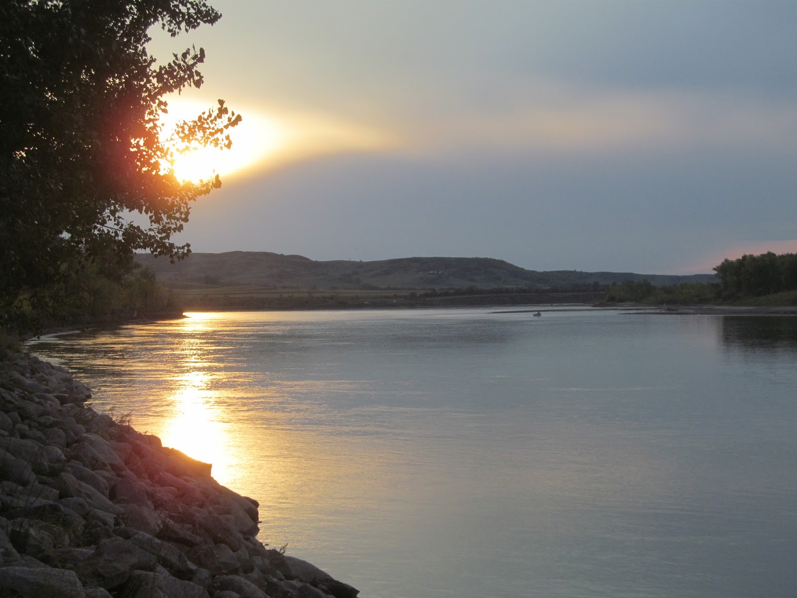
This is the best sunset shot that I could get, while we stayed here.  When we first got in, there was so much smoke in the skies, that it made the sunsets red, but we always had a lot of cloud cover.  Our campsite was right on the river.  We will be leaving tomorrow, but we've had a wonderful time with Glenn and Glo, and a fishing experience of a lifetime!  We will see them in Arizona this winter and will hike with Glenn.  

How sweet is this?  I do know several people thought we were crazy to order a little freezer, before we had any fish!  I guess we found out that there are Walleye in North Dakota!  The bottom portion is Northern.  Thanks to Glenn, our terrific fishing guide! 


Monday, September 18, 2017

Monday, September 18, 2017

I missed doing our blog yesterday, because I came home and crashed last night.  It was 38 degrees yesterday morning, and we went fishing at 8:30.  That is too darn cold for this old gal!  The wind blew, too, so it made it even more chilly.  We only got 6 fish yesterday, and I was froze to the core!  I didn't get a bite all day, so my luck really turned, but Glenn was again, the master fisherman.  I got a lot of 'snags' and I was quite frustrated!  Glenn's wife, Glo made dinner for us, and it was delicious.  Of course, we had Walleye, but she had so many other things to eat, that we were stuffed when we left their place.  She also, sent home a doggie bag for us for tonight. We got home and I was so wore out that I fell asleep on the sofa and didn't see any of the Packer game, and woke up and finally drug myself to bed!  I slept 13 hours!  OMG!  Only old people do that, right?  So, we told Glenn that today we wanted to leave at 10:00 this morning, which we did. It was probably 48 degrees when we got to the lake, and no wind, so it felt great.  Today was another slow day, but Glenn caught a Walleye and a very big Northern!  It was 37 inches long and weighed 15 pounds, so he had to put that stinky, slimy fish in his boat for 'Marlene'.   Jim caught two nice Walleye and a small Northern that we threw back in.  All in all, we caught 29 Walleye fish and two Northern that we kept.  Not bad for 4 days of fishing, when some of the old fishermen said they fished for four days and didn't get anything.  We credit it all to Glenn and his expertise.  We are done fishing, and will do some things in Mandan tomorrow and also go see the fort near here. We leave Wednesday, and it's been a great stay.

This is Glenn weighing the big Northern that he caught.  He grumbled the whole time he had to deal with that critter!  North Dakotan's don't like Northern's, I guess!  He says, why would you eat Northern, when you can get Walleye?  I'm sure he will disinfect his boat, after we leave. 

I decided to post a picture of the crank bait that Glenn uses, as we had never heard of crank bait before.  We always used live bait or regular fishing lures, when we fished. 


Saturday, September 16, 2017

Saturday, September 16, 2017

It was a cold and blustery day, but we knew if we wanted to visit the Interpretive Center, that tells about the Lewis and Clark expedition, we needed to go today.  We had been to Mandan in 2013, but we didn't take the time to visit here.  It was well worth the trip, but we still didn't have enough time to do justice to it.  From there, we went back to Mandan and met up with Ken and Arlene Lund, our hiking friends that we met in Arizona.  We had a nice visit and then they took us to the Mackenzie River Pizza place and we had an enjoyable meal and lots of catch up conversation!  Then back to their place for homemade rhubarb pie!  How can one turn that down?  It was great to see them, and we want them to come to WI for a visit sometime.  Ken is an avid Packer fan, and we want to take them to Lambeau.  So, no pictures yesterday, and I'm going to make up for it today!

We were welcomed to the Interpretive Center by this bigger than life, sculpture of Lewis and Clar, and their Indian guide, Sacagawea.

We understood that Lewis and Clark took a Newfoundland dog with them on their trip.  This is one HUGE dog!

We had pizza with Ken and Arlene Lund at the Mackenzie River Pizza Place.  Very good and the beer wasn't bad, either! Of course, we reminisced about our hiking adventures in The Valley!  Fun times with great friends! 

We snagged someone to take our picture outside the pizza place.  They had a huge Kodiak bear out front, and that was our chosen spot.  It reminded us of the horse in Fountain Hills, AZ, where they put all kind of utensils welded on it to construct the animal. 


                                  This is the state capitol building in Bismarck, North Dakota.

        This statue of Sacagawea and her baby, is on the grounds of the state capitol building.

We're fishing tomorrow and Monday!  Yippy Skippy!